URBAN CONSTELLATIONS: re-assessing the Airport and its Metro-Region

CHOI - Aerial Futures NYC

Image copyright XChange Architects

XChange’s Derrick Choi participated as a respondent at the URBAN CONSTELLATIONS Think Tank hosted by Aerial Futures from 05-06 April, 2018 at NewLab in the revitalized Brooklyn Navy Yard.

In response to one of the key discussion questions posed at the conference –  Multiple-airport cities present new challenges for passengers and urban dwellers…The fragmentation of airports in a single city, frequently owned and operated by different governing bodies, can lead to unpredictable and even confusing experiences.  How should we rethink the multiple-airport city more holistically?  –  Derrick shared some of XChange Architects’ ongoing research on the potential of airport systems in congested, large metro-regions to reappropriate extant infrastructure and civic spaces as virtual extensions of the airport network – effectively providing airports a set of operational “tentacles” in city centers to literally connect with passengers miles and hours before they set foot in the terminal building. As many airport functions are increasingly virtual and optimized – resulting in dramatic reductions in conventional space needs – imagine airports processing passenger checked baggage in urban centers and other alternative, off-airport locales, as illustrated in the renderings above that reimagine iconic urban spaces and infrastructure being repurposed as airport check-in facilities.  While this is a commonly accepted global practice, here in the United States, there remains considerable operational, jurisdictional, regulatory and cost-sharing complexities that can render some of the most simple ideas unachievable from the moment that are conceived. Surely, we can do better in our major U.S. urban centers.

AERIAL FUTURES Urban Constellations_2

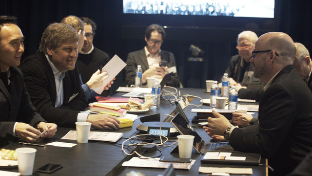
Think Tank proceedings at NewLab.  Image courtesy Aerial Futures

The day-long Think Tank sessions, highlighted by thought-provoking “impulse talks” by Mitchell Joachim of Terraform One and Campbell Hyers of Intersection remind us that the enhancement of the Airport’s relationship to its complex urban ecology can no longer be reliant on the physical solution alone; rather it must recognize that the passenger journey – and by extension, the “airport experience” – has been radically expanded from one’s door way to the jetway. Accordingly, a completely new set of expectations, standards and systems are emerging – leveraging atypical solutions, different perspectives and “out-of-the-industry” thinking to help deliver tomorrow’s airport systems.

Brookline’s Marathon Gateway: St. Mary’s

BM-3With the Boston Marathon less than 48 hours away, we are bracing for both the exhilaration and logistical insanity of the race on Monday.  One of the most intriguing aspects of the Marathon is its immediate and palpable urban intensity – transforming your everyday main street into the hub of the universe for a day.

One of our main corridors here in the Town of Brookline, Beacon Street, is one such destination along the Marathon route that becomes flooded with a sea of humanity on Marathon Monday.  As the final Brookline gateway before the final mile and a half of the Marathon, the St. Mary’s neighborhood, in particular, provides a uniquely dramatic backdrop for the final push: characterized by throngs of supporters (many from nearby Boston University) and the emergence of myriad large-scale graphics and banners, similar to the ones on the left and below at the St. Mary’s MBTA “T” stop.

BM-1

INSPIRATION – the supergraphic advertisement at the St. Mary’s T Stop during the 2012 Marathon.

Proposed - public artWe’ve always wondered if there was a way we could capture the excitement of Marathon Monday and somehow make it a permanent part of the urban fabric of this neighborhood.  The kinetic energy of movement – runners, cars, and trains – at St. Mary’s is a key design theme in our streetscape study for the Economic Development Department in the Town of Brookline.  In 2012, XChange Architects was invited to assist the Town Economic Development staff in a concept-level urban design charrette to help imagine the possibilities to enhance the commercial vibrancy of the St. Mary District by rethinking existing streetscape elements.

As a threshold between the Town of Brookline and the Fenway District  of Boston, we propose a public art installation for St. Mary’s in the form of a pair of large-scale directional signage that celebrates this sense of movement; borrowing from Fenway green while taking scalar clues from Marathon supergraphics.

St Mary - T

All photographs, images and drawings copyright Blair Hines Design Associates and XChange Architects LLC, unless otherwise noted.

Smallest Whole Foods Store Opens in Brookline: Saint Mary’s Re-imagined?

WF - opening weekendThe smallest branch of the Whole Foods empire opened yesterday morning in the St. Mary’s Commercial District in Brookline, Massachusetts.  In replacing the old Johnnie’s Fresh Market, a neighborhood favorite (disclaimer:  our previous studio was a mere 2 blocks away from the store), the new addition elicited a healthy debate about change, vibrancy, and the quality of community character in the commercial districts in Brookline.  Whatever your opinion of WF may be, there is no question that the new store will generate considerable  foot traffic to the area, which serves as a vital eastern gateway to the City of Boston – directly abutting Audubon Circle in the Fenway.

XChange Architects was invited by the Economic Development Department in the Town of Brookline in 2012 to assist in a concept-level urban design charette with commercial area stakeholders and the Brookline Chamber of Commerce to help imagine the possibilities to enhance the commercial vibrancy of the St. Mary District by rethinking existing streetscape elements:  wayfinding components, street fixtures, storefront interfaces, edge conditions, and the inter-relationship between the Commercial District and the MBTA above-ground “T” station.

Y:St Marys Street CharetteBHDA-BASE Layout1 (1)

PUBLIC ART – a site art concept using colorful footprints to literally map pedestrian foot traffic to highlight the MBTA platform’s role as a bridge in this neighborhood

St Mary - WP

STOREFRONTS – a potential storefront renovation concept for The Wine Press

St Mary - DD seating

STREET FURNITURE – a concept to provide modular retractable street furniture to subdivide public and private sidewalk spaces along Beacon Street in order to activate the deep, underutilized sidewalks on Beacon Street.

St Mary - T landscape 1 St Mary - T landscape 2

MBTA SUBWAY PLATFORM INTEGRATION THROUGH SITE INSTALLATIONS – a series of landscape interventions and site art installations were explored to improve the metering and flow of T customers accessing the platform

Design Collaborator:

Landscape Architect – Blair Hines Design Associates

All drawings, images, and photos are the copyright of Blair Hines Design Associates and XChange Architects LLC, unless otherwise indicated.